Complete Guide to Litter River Canyon National Preserve in Alabama, including things to do, how to get to the park, and so much more.
Little River Canyon National Preserve
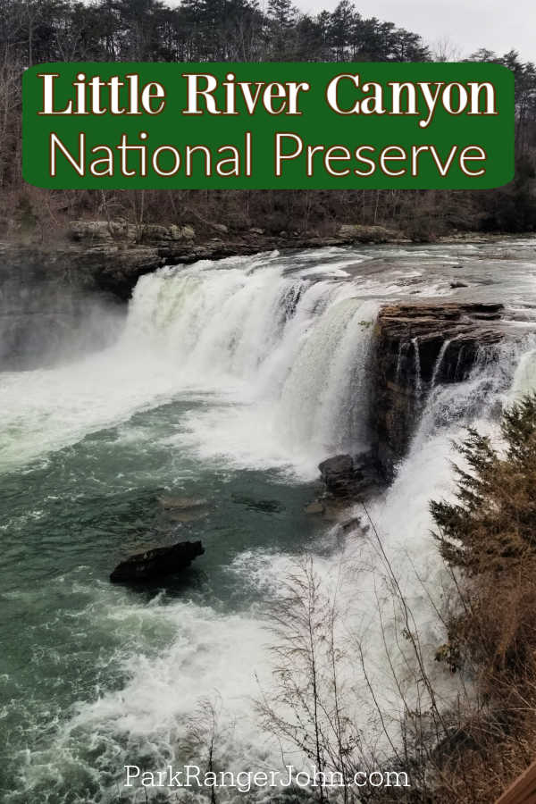
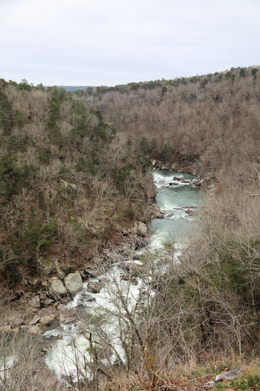
Little River Canyon National Preserve is located in Northern Alabama seventy miles from Huntsville. The canyon was formed by the Little River which flows for most of its length along the top of Lookout Mountain.
About Little River Canyon National Preserve
Part of the Appalachian Mountains the Little River has cut a deep canyon into the mountaintop creating cliffs hundreds of feet high in places. There is a scenic drive that takes you along many of the parks highlights.
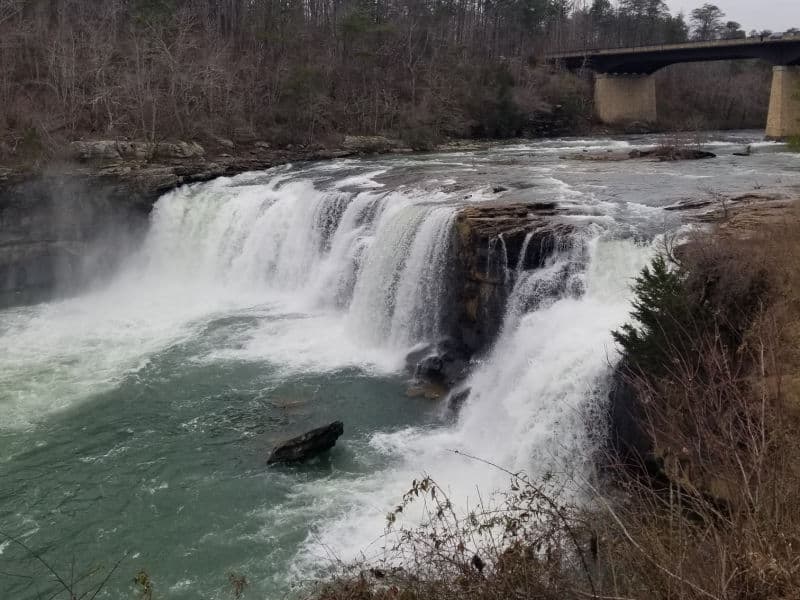
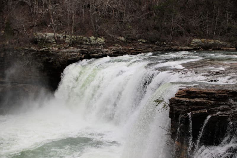
Little River Falls is 45 feet high and a gorgeous spot to enjoy. As you continue along the scenic drive multiple overlooks give you the option of looking out over the canyon.
Is Little River Canyon National Preserve worth visiting?
Yes, We really enjoyed the canyon rim drive. The views of the Southern Appalachians was gorgeous.
Sandstone Cliffs, large and small waterfalls, canyon rims, historic sites, and a ton of outdoor activities provide the perfect opportunity to enjoy a day outside exploring amazing natural resources.
History of Little River Canyon National Preserve
Little River Canyon National Preserve is located near the city of Fort Payne, Alabama and on top of Lookout Mountain. The boundary of the preserve contains over 15,000 acres.
The preserve protects what is said to be the longest mountaintop river in the nation, the Little River. Little River Canyon, originally named “May’s Gulf” is the deepest canyon in the state and also contains the highest waterfall in Alabama.
This area has been eroded by water over millions of years. What has formed are ridges, outcroppings and gorges consisting of sandstone and sedimentary rocks.
Carved into the flat top of Lookout Mountain is Little River Canyon which is one of the deepest canyon systems east of the Mississippi River. The Little River begins in northwest Georgia and ends its travel at Weiss Lake in northeast Alabama.
The gorgeous terrain gives way to a diverse list of recreational opportunities including swimming, hiking, fishing and some of the best white water rafting in the south. Only experienced rafters are allowed, especially at rapids called “Suicide” and “Avalanche.”
Before European settlement, this area was home to the Creek Indians for centuries. In 1813, General Andrew Jackson led what was known as the Red Stick or Creek Civil War.
The war began as a conflict inside of the Creek nation. In fact, this war was just as much Creek vs. Creek than it was Indians vs. Whites.
British and Spanish empires vying for land in the south supplied Creek groups with supplies and weapons. They cared most about preventing the United States from acquiring more land in the area.
The Creek War was fought for one year and in 1814, the Creek nation signed over 21 million acres to the United States. This was approximately half of present-day Alabama.
Nearly 2 million of these acres were set aside for Cherokee natives as land for hunting. The Cherokee fought alongside the U.S. during the Creek War.
Eventually, in 1819, Alabama was welcomed into the Union. For the Cherokee who sided with General Jackson during the war, their payout would be a short-lived advantage.
In 1835, the Cherokee signed over the rest of their land to the U.S. for $5 million. In 1838, over one thousand Cherokees were gathered in the Little River area and marched west on the Trail of Tears to Oklahoma.
Because Little River Canyon was too remarkable and rugged a landmark for entire armies to march through, it did not see substantial involvement in the Civil War.
While the main body of the mountain served as a rocky barrier, battles took place to the north and the south of Lookout Mountain. Union missions were led to cut off Chattanooga from the Western and Atlantic Railroad.
After the Union succeeded in taking Chattanooga, they intended to take Missionary Ridge, a location just east of Chattanooga.
In November of 1863, standing above Chattanooga and the Tennessee River, Lookout Mountain served as the battle site where Confederates were ultimately forced off the mountain to Missionary Ridge.
This battle, called “Battle Above the Clouds,” was followed by a Union victory at Missionary Ridge. Led by a future president, Ulysses S. Grant, the Confederates were forced south into Georgia.
The remainder of the Civil War did not include any further engagements at Lookout Mountain, but the site actually served as a “tourist destination” for Union soldiers.
At one point in time a photographer even set up a small studio to capture photos of people standing at picturesque locations on top of the mountain.
For around a decade in the 70s and 80s, a small theme park called “Canyonland Park” operated in the preserve. Along with the park, a group of Ft. Payne businessmen were permitted to construct a vehicle access-way through the canyon.
Hikers may see evidence of the old path. A zoo and ski lift were also build in the area; all that is visible from this park today are a few of the lift pedestals.
There are three distinct and beautiful waterfalls also located in the preserve, DeSoto Falls, Little River Falls, and Grace’s High Falls.
Grace’s Falls, the highest falls in the state, are created by Bear Creek and comes alive after abundant rainfall. A beautiful preserve for adventure seekers and historical buffs as well, Little River Canyon has been preserved by Congress since 1992.
Things to know before your visit to Little River Canyon National Preserve
Entrance fee
$15 day-use pass fee per vehicle
$35 annual pass available
Learn more about National Park Passes for parks that have an entrance fee.
$80.00 - For the America the Beautiful/National Park Pass. The pass covers entrance fees to all US National Park Sites and over 2,000 Federal Recreation Fee Sites for an entire year and covers everyone in the car for per-vehicle sites and up to 4 adults for per-person sites.
Buy your pass at this link, and REI will donate 10% of pass proceeds to the National Forest Foundation, National Park Foundation, and the U.S. Endowment for Forestry & Communities.
National Park Free Entrance Days -Mark your calendars with the five free entrance days the National Park Service offers annually.
Time Zone
Central Time Zone
Pets
Pets are allowed in all areas of the park, including the Little River Canyon Center, but they must be leashed at all times (using a leash no longer than 6 feet/2 meters).
This includes while in the water. It is your responsibility to clean up after your pet and dispose of their poop in a garbage can or take it home with you for disposal. Pets may not be left unattended at any time.
Cell Service
Cell service is intermittent and not always available in the park.
Park Hours
Sunrise to Sunset
Wi-Fi
Public Wi-Fi is available at the Little River Canyon Center.
Insect Repellent
Insect repellent is always a great idea when outdoors, especially if you are around any body of water.
We use Permethrin Spray on our clothes before our park trips.
Water Bottle
Make sure to bring your own water bottle and plenty of water with you. Plastic water bottles are not sold in the park.
Parking
The Little River Canyon Center has a parking lot for visitors.
Food/Restaurants
There are no restaurants in the park.
Gas
There are no gas stations in the park.
Drones
Drones are not permitted within National Park Sites.
National Park Passport Stamps
National Park Passport stamps can be found in the visitor center.
We like to use these circle stickers for park stamps so we don't have to bring our passport book with us on every trip.
The National Park Passport Book program is a great way to document all of the parks you have visitied.
You can get Passport Stickers and Annual Stamp Sets to help enhance your Passport Book.
Electric Vehicle Charging
EV charging stations are located in Fort Payne, Alabama
Details about Little River Canyon National Preserve
Size - 15,288 acres
Check out how the park compares to other National Parks by Size.
Date Established
October 21, 1992
Visitation
In 2021, Little River Canyon had 862,606 park visitors.
In 2020, Little River Canyon had 802,375 park visitors.
In 2019, Little River Canyon had 649,986 park visitors.
Learn more about the most visited and least visited National Parks in the US
National Park Address
GPS Address: 472 AL Hwy 35, Fort Payne, AL 35967.
4322 Little River Trail NE
Suite 100
Fort Payne, AL 35967
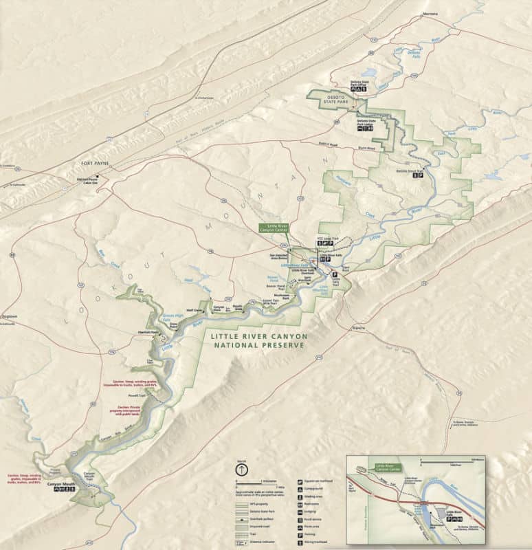
National Park Map
Where is Little River Canyon National Preserve?
Little River Canyon National Preserve follows along the Little River and covers approximately 40 miles from the northeast corner to the southwest corner.
Estimated distance from major cities nearby
- Birmingham, AL - 100 miles
- Atlanta, GA - 105 miles
- Nashville, TN - 200 miles
- Memphis, TN - 300 miles
- Lexington-Fayette, KY - 320 miles
- Louisville, KY - 350 miles
- Charlotte, NC - 350 miles
- Cincinnati, OH - 400 miles
- Jacksonville, FL - 415 miles
- St. Louis, MO - 490 miles
Estimated Distance from nearby National Park
Great Smoky Mountains National Park - 200 miles
Mammoth Cave National Park - 270 miles
Congaree National Park - 330 miles
New River Gorge National Park - 400 miles
Gateway Arch National Park - 490 miles
Where is the National Park Visitor Center?
The Visitor Center is located in Fort Payne, Alabama.
Little River Canyon Center is at 4322 Little River Trail NE (472 AL Hwy 35 for GPS)
Getting to Little River Canyon National Preserve
Closest Airports
- Chattanooga Metropolitan Airport (CHA)
- Huntsville International Airport (HSV)
- Birmingham Shuttlesworth International Airport (BHM)
International Airports
- Hartsfield Jackson Atlanta International Airport (ATL)
- Nashville International Airport
- Memphis International Airport
Driving Directions
The easiest way to access the park is by Alabama Highway 35 about 10 miles east out of Fort Payne, Alabama. Interstate 59 is the closest interstate.
Best time to visit Little River Canyon National Preserve
The optimal time to plan a trip to Little River Canyon National Preserve is either in the spring or fall because the weather is typically more comfortable and the natural surroundings are particularly picturesque during these times of year.
Weather and Seasons
The hot season begins from May 27 to September 19, with an average daily high temperature above 80 degrees.
The cold season begins from November 28 to February 27, with an average daily high temperature below 58 degrees.
The snowiest season begins from January 1 to February 13, with a snowfall of at least an inch a month. The most snow occurs in January, with an average of 1.3 inches.
Best Things to do in Little River Canyon National Preserve
We suggest planning a minimum of a few hours to explore Little River Canyon. If you plan to hike or spend time in the water you will want to plan more time.
JSU Little River Canyon Center
This visitor center is a partnership with Jacksonville State University. The visitor center includes a Grand Hall, HD Movie Theater, gift shop, natural history library, exhibits, classrooms, a back deck, outdoor amphitheater, and trails.
The building is LEED Silver Certified with geothermal heating and cooling, recycled materials, added insulation, and other innovative design elements.
It is a great place for social gatherings, special events, corporate retreats, and other events with easy access to a variety of recreational activities.
Scenic Drive
Enjoy a leisurely 23 miles drive down AL Highway 176 Little River Canyon Rim Parkway and enjoy the eight overlooks to stop and enjoy the scenery. There are picnic tables available at the overlooks to enjoy a picnic or snack break.
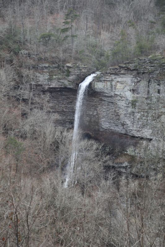
The overlook at Grace's High Falls provides a great view of the 133-foot-high waterfall.
One thing to know is Grace's High Falls is a seasonal waterfall that may not have much water during the summer.
There are picnic tables along the scenic drive that are great for lunch or a nice snack stop.
Travel time from the Little River Canyon Center to Canyon Mouth Park along the Little River Canyon Rim Parkway takes approximately 45 minutes (without stopping at overlooks)
The 11 miles from Eberhart Point to Canyon Mouth Park is steep and windy in areas and impassable to trailers and RVs.
Junior Ranger Program
You can become a Little River Canyon Junior Ranger by picking up a program at the Little River Canyon Center. The booklet can be completed at the visitor center.
Waterfalls
There are three named waterfalls in Little River Canyon National Preserve along with many unnamed seasonal waterfalls.
Little River Falls
This is the most popular waterfall in the park. Little River Falls is 45 feet tall and shows how the Little River has carved its way through the sandstone bedrock to create the canyon.
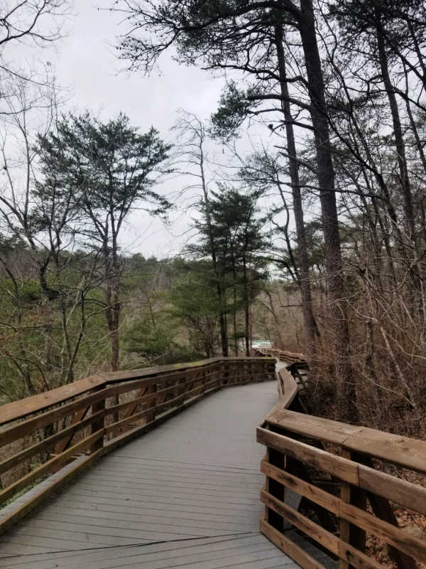
There is an ADA accessible boardwalk that leads down to a closer view of the falls.
Little Falls
Formerly known as Martha's Falls, this mini-waterfall was formed by water cascading over the sandstone ledge the width of the river.
This area is a favorite swimming spot in the summer.
Access to Little Falls can be had from the paved Little River Falls parking lot on Highway 35. The Little Falls Trail is a .75 mile hike which leads to 137 stone stairs down into the canyon to the river.
This area is incredibly popular in the late spring and on summer weekends! The parking lot is normally full by 11am.
Grace High Falls
Grace High Falls is a 133 foot tall seasonal waterfall that is the tallest above ground waterfall in Alabama. This waterfall is weather dependent and does not flow year-round. There is a viewing platform on Little Rier Canyon Rim Parkway.
Kayaking
If you are an experienced kayaker you can check out the class 3 and 4 rapids on the Little River during high-water periods. Make sure and check with the visitor center to see what water levels are before heading out on the river.
Backcountry
There are 23 miles of road within the Wildlife Management Area of Little River Canyon Preserve. this area is accessible to 4-wheel drive vehicles, horseback riders, bicyclist, and hikers.
Off-Highway Vehicles (OHVs) such as ATVs, UTVs, and non-street legal dirt bikes are NOT allowed on any road at Little River Canyon National Preserve.
Hiking in Little River Canyon National Preserve
Always carry the 10 essentials for outdoor survival when exploring.
Bridge Trail - .75 miles, easy, trailhead is at the Little River Canyon Center
Path to Learning Trail - .5 miles, easy, trailhead is at the Little River Canyon Canter
Little Falls Trail - .75miles, moderate, trailhead is at the Little River Falls parking lot.
Little River Falls Boardwalk - .1 mile, easy, Trailhead is at the Litter River Falls parking lot.
Lower Two-Mile Trail - .1 mile, arduous and steep, The trailhead is on the Little River Canyon Rim Parkway.
Powell Trail - .75 miles, moderate, The trailhead is on the Little River Canyon Rim Parkway.
Canyon Mouth Trail - 1 miles, easy, the trailhead is at Canyon Mouth Park.
DeSoto Scout Trail - 16 miles, moderate to arduous, there are access points along Road 5 at the north end and in DeSoto State Park.
YCC Loop Trail - 3.9 miles, moderate, trailhead is on the south end of Road 5.
Beaver Pond Trail - Beaver Pond Trail is a 1.5 mile loop. This trail offers easy walking and is located on top of the mountain. The trailhead is on the Little River Canyon Rim Parkway.
Eberhart Trail - Eberhart Trail is a ¾ miles trail from the top to the bottom of the canyon. Once you are at the bottom of the canyon, you can hike as far as you want. Keep in mind, you have to come back up the ¾ miles to get back to the top. The trailhead is on the Little River Canyon Rim Parkway.
How to beat the crowds in Little River Canyon National Preserve?
We did not experience any crowds during our visit but we visited during the off-season. During the summer I would plan to arrive early and be prepared for crowds especially at the swimming areas.
Where to stay when visiting Little River Canyon National Preserve
There are no National Park Lodges available within the park. Little River Canyon National Preserve does not offer any type of lodging at this time.
Located nearby, DeSoto State Park offers motels, cabins, chalets, and a campground. The state park is located on the north end of the Backcountry Area near Mentone, Alabama. It is approximately 10 miles from Little River Falls.
The majority of lodging near Little River Canyon can be found in Fort Payne, Alabama.
Additional nearby lodging includes:
Hampton Inn Ft Payne - Located close to Alabama Fan Club and Museum and Fort Payne Depot Museum, Hampton Inn Ft Payne provides dry cleaning/laundry services, a gym, and a business center. Stay connected with free in-room Wi-Fi, and guests can find other amenities such as a snack bar/deli.
Fairfield Inn & Suites by Marriott Rome - look forward to dry cleaning/laundry services, a bar, and a restaurant. Stay connected with free in-room Wi-Fi.
Hawthorn Suites by Wyndham Rome - Located close to The Forum and Rome Area History Museum, Hawthorn Suites by Wyndham Rome provides a terrace, dry cleaning/laundry services, and a bar. Treat yourself to a massage at the onsite spa. Stay connected with free in-room Wi-Fi, and guests can find other amenities such as a gym and conference space.
Holiday Inn Express Ft Payne - Take advantage of free to-go breakfast, dry cleaning/laundry services, and a gym at Holiday Inn Express Ft Payne, an IHG Hotel. Stay connected with free in-room Wi-Fi, and guests can find other amenities such as a 24-hour business center.
Click on the map below to see additional lodging and vacation rentals near the park.
Camping
Camping is allowed at three designated primitive campgrounds in the park. More developed campgrounds are available at nearby DeSoto State Park.

For a fun adventure check out Escape Campervans. These campervans have built in beds, kitchen area with refrigerators, and more. You can have them fully set up with kitchen supplies, bedding, and other fun extras. They are painted with epic designs you can't miss!
Escape Campervans has offices in Vancouver, Seattle, Portland, San Francisco, Las Vegas, Los Angeles, Phoenix, Salt Lake City, Denver, New York, and Orlando
Parks Near Little River Canyon National Preserve
Russell Cave National Monument - 55 miles
Chickamauga and Chattanooga National Military Park - 51 miles
Kennesaw Mountain National Battlefield Park - 90 miles
Freedom Riders National Monument - 60 miles
Birmingham Civil Rights National Historic Site - 97 miles
Printable list of US National Parks in Alphabetical Order
Check out all of the National Parks in Alabama along with neighboring Florida National Parks, Mississippi National Parks, Georgia National Parks, and Tennessee National Parks
Make sure to follow Park Ranger John on Facebook, Instagram, Pinterest, and TikTok


Leave a Reply