Published: · Updated: by JohnTillison · This post may contain affiliate links
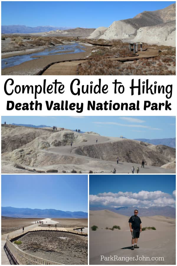
Complete Guide to Death Valley Hikes
Epic Guide to Death Valley Hikes! Spending time hiking Death Valley is perhaps the best way to get out and explore its 3.4 million acres! Here you can find everything from salt flats and sand dunes to mountain peaks.
Complete guide to Death Valley Hikes
No matter the season, there is a trail you can hike at Death Valley. The summer brings extreme heat and drought so I always recommend going up into the mountains.
Dantes Peak and Telescope Peak are great places to explore during the summer.
When the temperatures drop in the winter, make sure to explore the trails below sea level like Badwater Salt Flat, Mesquite Flat Sand Dunes, and the Sand Creek Interpretative Trail.
If you have only one day in the park, I would suggest hitting some of the easy trails as you will get to see more of the park and get a rest in between hikes.
Spring is a great time to look for wildflowers. Both Spring and fall are a great time to hike, just plan on hiking earlier in the day before the heat takes over.
I also can't emphasize the importance of knowing your limits, carrying plenty of water, and always carrying the 10 essentials for outdoor survival.
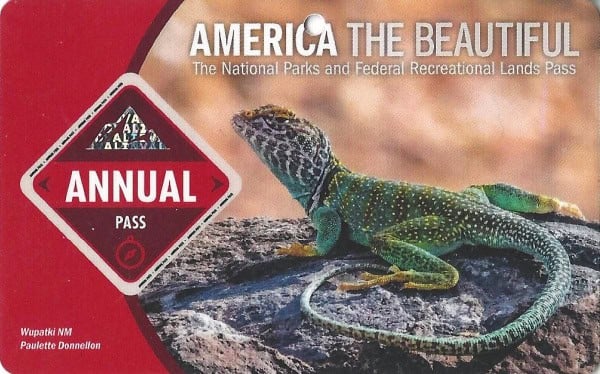
Death Valley National Park Entrance Fee
Park entrance fees are separate from camping and lodging fees.
Park Entrance Pass - $30.00 Per private vehicle (valid for 1-7 days from the date of purchase)
Park Entrance Pass - Motorcycle - $25.00 Per motorcycle (valid for 1-7 days from the date of purchase)
Per-Person Entrance Pass - $15.00 Visitors 16 years or older who enter on foot, bicycle, or as part of an organized group not involved in a commercial tour.
Annual Park Entrance Pass - $55.00, Admits pass holder and all passengers in a non-commercial vehicle. Valid for one year from the month of purchase.
$0.00 for Education/Academic Group
$35.00-$75.00 for vehicles with 1-6 seats commercial sedan, $25 per vehicle plus $10.00 per person
$75.00 for commercial van with 7-15 seats
$100.00 for commercial van with 16-25 seats
$200.00 for commercial motorcoach with 26+ seats
$15.00 per person for non-commercial group (16+ persons) ex. scout groups, church groups, etc.
$80.00 - For the America the Beautiful/National Park Pass. The pass covers entrance fees to all US National Park Sites and over 2,000 Federal Recreation Fee Sites for an entire year and covers everyone in the car for per-vehicle sites and up to 4 adults for per-person sites.
Buy your pass at this link, and REI will donate 10% of pass proceeds to the National Forest Foundation, National Park Foundation, and the U.S. Endowment for Forestry & Communities.
There are quite a few easy Death Valley Hikes which makes it great for all visitors. As with all hikes in Death Valley you will want to be prepared for the weather and always carry water with you.
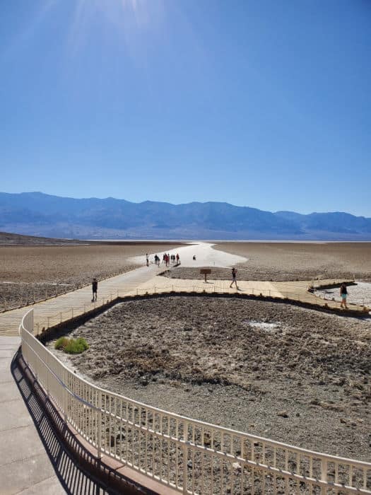
Badwater Salt Flat
Length: 1 mile (1.6km) out and back hike to the edge of a salt flat.
Time: 30-45 minutes
Difficulty: Easy
Elevation Gain: Flat
Location: 30 minutes south of Furnace Creek.
Restroom at Trailhead: There are several vault toilets located in the parking lot.
All you have to do is simply walk out onto the salt flat from the trailhead. You will get a fantastic view of the entire valley.
Just make sure not to do this trail from late spring to fall in the heat of the day as there is no protection from the sun.
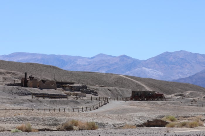
Harmony Borax Works
Length: 0.4 mi (0.6km) loop trail.
ADA accessible: Yes
Time: 30 minutes round trip
Difficulty: Easy
Elevation Gain: 50 feet (0.8km)
Location: 1 mile (1.6km) west of Furnace Creek
Restroom at Trailhead: There are no restrooms at the trailhead. The closest restrooms are located at the Furnace Creek Visitor Center approximately 1 mile east.
Again, this is an easy trail with several interpretative signs and a close-up of what remains today from the famous 20 mule team (actually 18 mules and 2 horses).
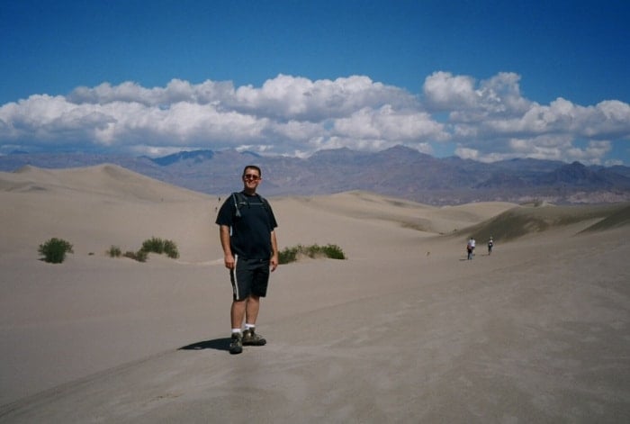
Mesquite Flat Sand Dunes
Length: 2 miles (3.2km) out and back trail
Time: 1.5 hours round trip
Difficulty: Easy to Moderate
Elevation Gain: 185 feet (65m)
Location: Located in Stovepipe Wells Village
Restroom at Trailhead: There are vault toilets located in the parking lot.
The Mesquite Flat Sand Dunes is one of my all-time favorite hikes in the National Park System! It's just you and the sand and you hike your way to the top of the last dune. The views are outstanding!
Natural Bridge
Length: 1 mi (3.2km) out and back Hike
Time: 45 minutes round trip
Difficulty: Easy
Elevation Gain: 86 feet (26m)
Location: The unpaved Natural Bridge Road is 13.5 miles (22km) south of CA-190 on Badwater Road and is typically passable to cars.
Restroom at Trailhead: A vault toilet located in the parking lot.
Another nice short hike that leads to a natural bridge. The bridge arches over the canyon bottom and you can choose to turn around or continue up to where it ends at a dry waterfall.
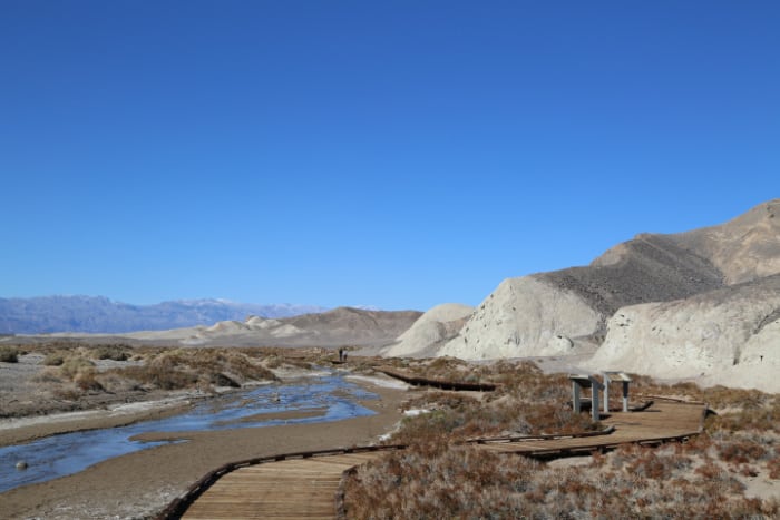
Salt Creek Interpretive Trail
Length: 0.5 mi (0.8km) loop trail.
ADA Accessible: Yes
Time: 30 minutes round trip
Elevation Gain: Flat
Location: Salt Creek Road located 13 miles (20km) west of Furnace Creek on CA-190. The unpaved Salt Creek Road is typically passable for cars.
Parking: The open gravel parking area is large enough for RV's and buses.
Restroom at Trailhead: There are Vault toilets located in the parking lot.
Best Time to hike Salt Creek interpretative Trail: The best time to hike the Salt Creek Interpretative Trail is February through April when the Salt Creek Pupfish are in spawn.
This is another nice hike in Death Valley. This short loop trail follows along Salt Creek and is fun to watch out for the pupfish that only live here in the park. I also think this area is rather photogenic and surprises many people that does not know much about the park.
Moderate Hikes
These moderate hiking trails are spread throughout Death Valley NP! Please make sure you are prepared for these trails and the weather.
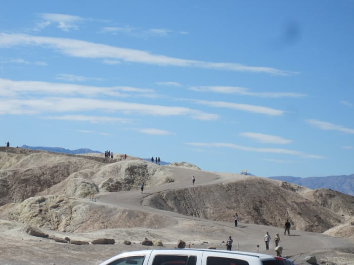
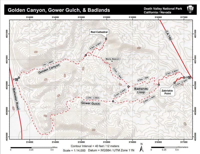
Badlands Loop
Length: 2.7 mile Loop trail
Time: 1.5 - 2 hours round trip
Difficulty: Moderate
Elevation Gain: 535 feet (163m)
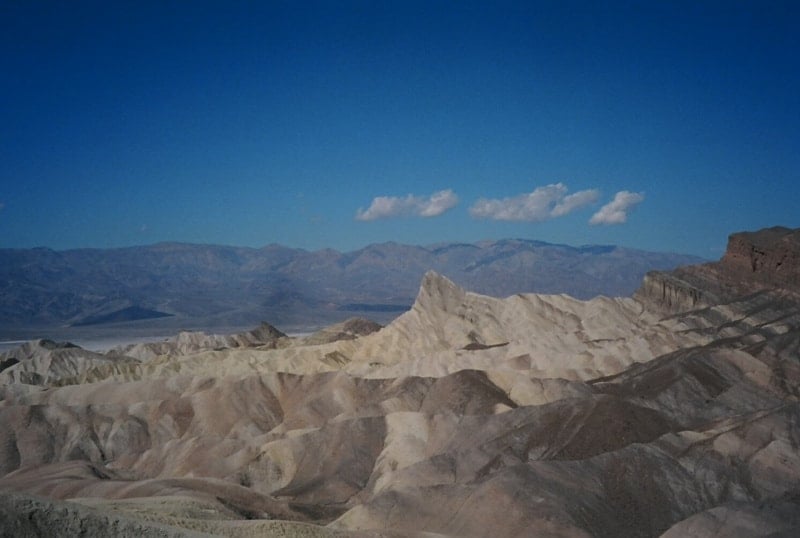
Location: Zabriskie Point Trailhead on CA-190 3.5 miles east of the Badwater Road intersection
Restroom at Trailhead: There is a vault toilet located at the trailhead.
This trail starts off from the most popular viewpoint in the park so be prepared for crowds. The trail starts off going down an obvious gully just north of the parking lot. The trail leads hikers down Gower Gulch.
The trail will pass through the badlands section where several abandoned Borax mines exist. Of course, you can hike more than just the Badlands Loop, you can add Gower Gulch and or Golden Canyon for a longer, more strenuous hike.
You can also hike the whole thing, known as hiking the complete circuit making a 7.8-mile hike!
Golden Canyon to Red Cathedral
Length: 3 miles (4.8 km) out and back trip
Time: 1.5 to 2 hours round trip
Difficulty: Moderate
Elevation: 577 feet (176m)
Location: Golden Canyon Trailhead located 2 miles south of CA-190 on Badwater Road.
Closest Restroom: A vault toilet is located in the Golden Canyon parking lot.
Golden Canyon is a gentle uphill hike going through a corridor of golden canyon walls. Hikers must plan on minor rock scrambling as it is necessary to complete the entire route over short (4ft / 1.2m) ledges and duck under low overhangs.
Gower Gulch Loop: 4.3 mi (6.9km)
Length: 4.3-mile loop trail.
Time: 2.5 hours round trip
Difficulty: Moderate
Elevation Gain: 850 feet (259m)
Location: Start at the Golden Canyon Trailhead located 2 miles south of the Ca-190-Badwater Road intersection.
Restroom at Trailhead: A vault toilet is located in the Golden Canyon parking lot.
The hike starts with a gradual uphill climb through the towering golden canyon walls. The trail will pass through the badlands and then turn back down Gower Gulch towards the trailhead.
Darwin Falls
Length: 2 miles (3.2km) out and back trail
Time: 1.5 - 2 hours round trip
Difficulty: Moderate
Elevation Gain: 450 feet (137m)
Location: The unpaved Darwin Falls Road is located 1.2 miles (2km) west of Panamint Springs on CA-190. Darwin Falls Road is typically passable to the trailhead by car, however, it is much more comfortable in a high clearance vehicle. Traveling from the town of Darwin to the trailhead is recommended for 4x4 high clearance vehicles only. Steep grades and unmarked intersections. Traveling to Darwin from the falls is not recommended.
Restroom at Trailhead: There are no restrooms at the trailhead. The closest restroom is located at the privately owned Panamint Springs Resort.
The best time of year to complete this hike is from October through June.
This hike is unexpected for most park visitors, especially for those who have not done their research. This is actually a great birding trail with over 80 species being identified here alone.
This is because of the water coming down from Panamint Springs above that has created the 25 foot Darwin Falls that we are all interested in hiking to.
When you hike up this canyon, you will be greeted with green shrubbery, willow, and cottonwoods. Nothing that you would expect while visiting the hottest, driest place on earth. The rocks near the falls are extremely slippery so make sure to watch your step.
Also, there is no swimming in the water as this is the drinking source for Panamint Springs.
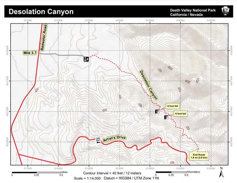
Desolation Canyon
Length: 3.6 miles (5.8km) out and back hike Time: 2.5 hours round trip Difficulty: Moderate to Difficult Elevation Gain: 600 feet (183m) Location: The short unpaved Desolation Canyon Road is located 3.7 miles (6km) south of CA-190 on Badwater Road. Typically passable to sedans. Restroom at Trailhead: There is no restroom at the trailhead. The Golden Canyon parking lot located 1.7 miles (2.7km) north has a vault toilet in the parking lot.
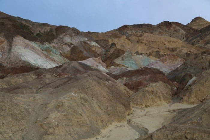
Desolation Canyon runs along the western edge of the Black Mountains where a maze of drainages reveals colors reminiscent of neighbor Artist's Palette.
Fall Canyon
Length: 6 miles (9.7km) out and back trail
Time: 3.5 hours round trip
Difficulty: Moderate to Difficult
Elevation Gain: 2,460 feet (752m)
Location: The 2.7 mile (4.3km) unpaved two-way section of Titus Canyon Road is located 11.9 miles north of CA-190 on Scotty's Castle Road.
Restroom at Trailhead: There is a vault toilet in the parking lot.
Fall Canyon is a great option for those a bit more adventurous and who want to beat the crowds and see wildlife. The big attraction is the narrows section with beautiful colors in the canyon walls. There are also ample opportunities to see wildlife like chuckwallas and bighorn sheep. To find the trail, look behind the restroom and locate the trail. In less than a mile the trail drops steeply into a wash. Once into the wash, go to the right up the drainage and the canyon will come into view. Follow the way up to the 25 foot dry waterfall and turn back around.
Mosaic Canyon
Length: 4 miles (6.4km) out and back trail
Time: 2.5 - 3 hours round trip
Difficulty: Moderate to Difficult
Elevation Gain: 1,200 feet (366m)
Location: The 2.3 mile (3.7km) unpaved Mosaic Canyon Road is located in Stovepipe Wells Village just across from Stovepipe Wells Campground.
Restroom at Trailhead: There is a restroom at Stovepipe Wells Village at the general store and restaurant.
the first .2 miles of this hike take you through the polished marble surfaces that make this hike a favorite to many park visitors. Like all canyons that have been created by water, know the weather forecast and flash flood danger before entering and slot canyon. The first mile of this trail is easy with a gradual incline but can be done by most people and the rock canyons are stunning. The last part requires some scrambling and route finding so go as far as you are comfortable with and head back.
Ubehebe Crater Loop
Length: 1.5 mile (2.4km) loop trail
Time: 1 hour round trip
Cautions: Not good for those with a fear of heights.
Elevation Gain: 500 feet (152m)
Location: 8 miles (13km) west of Scotty's Castle
Restroom at Trailhead: There are no restrooms at the trailhead. The closest restrooms are located at the unstaffed Grapevine Ranger Station 5 miles (8km) east of the crater.
The Ubehebe Crater Loop Trail is best to go counterclockwise as you get the elevation portion of the hike done right away. The views around the crater are fantastic but bring plenty of water and wear sunscreen as there is no protection from the sun. Be prepared for a much more difficult hike if you plan on going down into the crater as it will easily take you twice as long to get back up than going down. Some people will have difficulties just trying to get back up with the loose rock. Make sure to bring trekking poles.
Willow Canyon
Length: 4.2 miles (6.8km) out and back trail Time: 2.5 hours, round trip Difficulty: Moderate to Difficult Elevation Gain: 776 feet (237m) Location: An unmarked gravel access road is located on Badwater Road 31.5 miles south of CA-190 between mile markers 31 & 32. The access road is less than 0.5 miles (0.8km) long and is typically passable to a sedan. Same as Sidewinder Canyon. Restroom at Trailhead: There are no restrooms nearby.
There is no signage for this route. Go north/northeast that wraps around the foothills and head towards the deep canyon in the mountain. The trail is kinda boring for the first half but the second half is amazing as it turns into a cool little slot canyon that ends with a seasonal waterfall.
Difficult Hikes
Corkscrew Peak
Length: 7 miles out and back trail
Time: 4-7 hours roundtrip
Difficulty: Difficult
Elevation Gain: 3,093 feet
Location: From CA-190 at Stovepipe Wells, turn onto Scotty's Castle Road. Drive .5 mile then turn onto Daylight Pass Road towards Beatty, Nv. Drive approx 7.9 miles to a small and unassuming pull-off on the side of the road north of mud canyon.
Restroom at Trailhead: The closest restroom is at Stovepipe Wells.
The first two and a half miles of the trail are easy with a lot of loose sand and gravel. The last 1.5 miles is a 2000 foot climb! You are going up a very steep incline with scree and very rocky and almost guarantee that you will be huffing and puffing by the time you make it to the top! Trekking poles are very helpful. You will know that you have reached the top when you see breathtaking views and the metal box with the hiker's logbook inside. Make sure to enjoy the moment, after all if you made it up all the way, you deserve this view.
Location: There is no designated trailhead for this hike. Simply park on the road shoulder on the eastbound side of CA-190 at mile marker 89.
Restroom at Trailhead: No, there are vault toilets are located in the Mesquite Dunes parking lot located one mile east of the trailhead.
This is an unmarked trail that takes you to the Little Canyon. Here you will see the canyon walls filled with mineral deposits with bright reds, whites, and yellows. There is also an arch in Little Bridge Canyon as well as Little Bridge. Make sure to check-in at the park visitor center for the trail map and route or click the link above.
Panamint Dunes
Length: 8 miles (12.8km) out and back
Time: 4-5 hours round trip
Difficulty: Moderately difficult
Elevation Gain: 1,028 feet (313m)
Location: Unmarked cross country route off the unpaved Lake Hill road, approximately 4.5 miles east of Panamint Springs on the north side of CA-190. Access to the trailhead requires a high clearance vehicle.
Restroom at Trailhead: No, the closest restrooms are located at the Panamint Springs Resort or Emigrant Canyon Rest Station.
Panamint Dunes is a 3.5-mile trek each way through the desert. This is a great trail to do in the spring when the wildflowers are in bloom and it is not in the heat of the summer.
There is no designated trail so you will be walking towards the sand dunes across the desert. It is suggested to have a GPS or compass to be able to find your way back.
It's easy to see the large dunes on your way there but you will not see any vehicles on your way back and without a designated trail, it is easy to find yourself disoriented and lost.
The hike itself is a bit boring but the payoff is that you could very well have the dunes all to yourself.
If you want to explore dunes but don't want to have to take a 7-mile hike to see them, go hike the Mesquite Flat sand dunes. The trailhead is right by the dunes but you will be with other park visitors.
Sidewinder Canyon
Length: 5 miles (8.4km) out and back trail
Time: 6 hours round trip
Difficulty: Extremely Difficult
Elevation Gain: 1,580 feet (482m)
Location: An unmarked gravel access road is located on Badwater Road 31.5 miles south of CA-190 between mile markers 31 & 32. The access road is less than 0.5 miles (0.8km) long and is typically passable to a sedan.
Restroom at Trailhead: There are no restrooms nearby.
This is a hike for the more adventurous hiker that comes to the park and likes to get away from the crowds. Sidewinder Canyon is a physically and mentally demanding hike.
There are no signs and you are entering an area designated as wilderness. You will climb over vertical ledges over 6 feet high and crawl into tight spaces that are 1.5 feet wide.
It's a steady incline through desert rocks for the first mile. You will pass by several side canyons that you can explore.
It is a great idea to have a headlamp/flashlight and trekking poles for this hike. The first slot has a narrow entrance and is dark inside.
The third and fourth slots tend to be the hiker's favorites so if you plan on taking this hike, make sure to give yourself plenty of time to explore.
Location: From CA-190 follow Emigrant Canyon Road past the Wildrose Campground to the parking area at the Charcoal Kilns. The final 5 miles is a maintained gravel surface typically passable in a sedan. 25 foot vehicle limit.
Restroom at Trailhead: There is a vault toilet in the parking lot.
Telescope Peak is best hiked between June and October. The Mahogany Flat Campground is located at the trailhead and is the ideal place to spend the night before making this hike.
This will give you time to acclimate to the high elevation. This is pretty important as you start off hiking at 8,000 feet to the highest point in Death Valley at 11,049 feet in elevation.
You will pass through Pinyon Pines, Limber Pines, and my favorite Bristlecone Pines!
Once you reach the summit, you will have absolutely breathtaking views of the lowest point in the western hemisphere at Badwater Basin as well as the tallest mountain peak in the Contiguous U.S., Mount Whitney at 14, 505 feet.
Wildrose Peak
Length: 8.4 miles (13.5km) out and back trail
Time: 6 hours round trip.
Difficulty: Difficult
Elevation Gain: 2,200 feet (671m)
Location: From CA-190 follow Emigrant Canyon Road past the Wildrose Campground to the parking area at the Charcoal Kilns. The final 2 miles is a maintained gravel surface typically passable in a sedan. 25 ft vehicle limit.
Restroom at Trailhead: There is a vault toilet in the parking lot.
The Wildrose Peak Trailhead is located at the Wildrose Charcoal Kilns, 10 beehive structures that were built to store fuel for the Modock Consolidated Mining Company in the late 1800s.
This is an easy trail to follow and has a climb all the way to the top. The good news is that it is all downhill from the summit. Remember that you are in high elevation country here which is typically a good 30 degrees cooler than the basin of the park.
This also means that you can easily run into snow in the winter months. I would also recommend trekking poles and some sort of cleat for your boots in the winter. The hike has a beautiful view at the end.
Death Valley Semi-private Day tour from Las Vegas - This full-day tour includes either a buffet breakfast or an a la carte lunch and bottled water as you travel via comfortable coach to the park stopping at highlights like the Rhyolite Ghost Town and the most famous Area 51 Alien Center. You then enter Death Valley with stops at Mesquite Flat Sand Dunes, Burned Wagons, point, Furnace Creek Visitor Center, Badwater Basin, Artists Palette, Zabriske Point, and Dante's View (when open) before heading back to Las Vegas. Click here to book this tour for Death Valley Semi-private Day Tour from Las Vegas.
Death Valley Sunset and Starry Night Tour from Las Vegas - Discover Death Valley by night and day on the 12 hour tour roundtrip from Las Vegas, Nevada! This tour allows you to discover several areas of the park by day including Dante's View (When Open), Badwater Basin, Artists Palette, Zabriske Point and then enjoy the night sky after sunset before heading back to Las Vegas. Click here to book this tour for Death Valley Sunset and Starry Night Tour from Las Vegas.
Lodging Options
National Park Lodges often sell out months in advance; below is a list of hotels/lodges near the park.
Holiday Inn & Suites Pahrump - free continental breakfast, golfing on site, and a terrace. For some rest and relaxation, visit the hot tub. Enjoy the 24-hour gym, as well as activities like tennis. Free in-room Wi-Fi is available to all guests, along with laundry facilities and a bar. Click here to book your Stay at the Holiday Inn Express & Suites Pahrump
Best Western Pahrump Oasis - free continental breakfast, a bar, and a 24-hour business center. For some rest and relaxation, visit the 2 hot tubs. Free Wi-Fi in public areas and a restaurant are available to all guests. Click here to book your stay at Best Western Pahrump Oasis.
Click the map below for a full list of lodging options available near the park.
For a fun adventure check out Escape Campervans. These campervans have built in beds, kitchen area with refrigerators, and more. You can have them fully set up with kitchen supplies, bedding, and other fun extras. They are painted with epic designs you can't miss!


Leave a Reply